Baker Family Cemetery
Cemetery Quick Links
Adams on CR 410
Adams on CR 262
Algerita
Baker Family
Bend
Big Uncle
Bowser Bend
Brister Ranch Grave
Brown, Shorty
Butcher
Catclaw (Weems)
Cedar Brake Cemetery
Chappel Cemetery
Cherokee (Hanna)
China Creek
Colony
Crawford
Clark, W. N. Family
Davidson
Deer Creek
Ellis (Rock Shoals)
Estep Family
Farr
Feazle Rock
Harkeyville
Harmony Ridge
Harris
High Valley
Hillcrest
Hinton
Holt
Jones
Kelley Family
King Family
Kuykendall
Latham
Linn
Locker
Mahan
Maxwell
May
McCarty
McConnell grave
McMillin
McPherson
Merrill Graves
Mesquite
Montgomery
Neel
Richland Springs (not available)
San Saba City
Shaw Bend
Sides
Sloan (Henderson)
Smelzer (Rough Creek)
Smith, John Wesley Family
Spring Creek
Sutton
Terry
Union Band
Varga Chappel
Union Band
Wallace Creek
Location: The Baker Family Cemetery is located in Southwest San Saba County near Rock Shoals on the north side of the San Saba River on the O. P. Leonard property
GPS: Latitude: 31.1956o N Longitude: 98.9045o W
Directions: From San Saba city limit go 2.2 miles west on U. S. 190 to FM 2732. 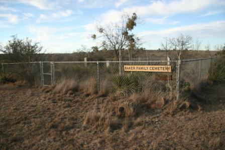
Turn left onto FM 2732 (Sloan Road)
Go 7.1 miles on FM 2732 to CR 340.
Turn right onto CR 340. Go north. Cross the San Saba River on narrow low water bridge.
Continue north 1. 1 mile on CR 340 to top of hill at house on right.
The cemetery is about 100 yards behind the house.